Land Surveying in Harris, Chambers, and Liberty Counties, Texas
Hutchison & Associates’ professional surveyors perform complete surveying services using the latest technology available. Playing an integral role in land development, our surveyors research, collect and analyze data, locate boundary corners, take accurate measurements of buildings and other improvements, and use that information to generate survey maps, show monumentation, and identify property ownership.
PURPOSE OF A LAND SURVEY
Land surveys are performed for a variety of reasons. They determine boundaries of properties as well as easements, encroachments, ownership, and are useful in avoiding or solving boundary disputes. These measurements are necessary to guide the development of land and to ensure that developers and land owners have satisfied building code requirements and regulations.
For more survey information, call 281-422-8213 or contact us at our Baytown, TX, location today.
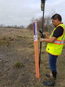
Construction Surveying for Industrial & Refinery Facilities in Harris, Chambers, and Liberty Counties, Texas
Construction surveying for industrial and refinery facilities requires a high level of precision, regulatory knowledge, and practical construction experience. In Harris, Chambers, and Liberty Counties, Hutchison & Associates provides professional land surveying services led by Texas Registered Professional Land Surveyors (RPLS) with extensive experience supporting refinery, petrochemical, and heavy industrial construction projects.
Our firm focuses on construction-driven surveying services for industrial facilities, working closely with owners, engineers, and contractors from early site development through final construction. We understand the complexity of refinery and plant environments and deliver survey data that is accurate, field-ready, and aligned with real construction needs.
Using advanced surveying technology and proven field procedures, our RPLS-directed team provides the precise measurements required for construction staking, boundary surveys, as-built surveys, and regulatory compliance. Reliable survey control is essential in industrial and refinery settings, where accuracy directly impacts safety, efficiency, and project success.
Whether supporting new construction, expansions, or facility upgrades, Hutchison & Associates offers the expertise and professionalism needed to keep complex industrial projects moving forward across Southeast Texas.
Types of Surveys
Boundary Surveys determine the property lines and corners of tracts of land and parcels.
Construction Surveys, also considered construction staking, provide measurements for reference points that affect construction on a parcel of land such as elevation, horizontal and vertical positions, and dimensions.
Subdivision Surveys, or platting, are used to divide one parcel of land into two or more parcels. These surveys are used for legal titles for each parcel.
Topographic Surveys determine the elevation points of a land parcel showing the contour lines of the natural and man-made features of the property.
As-Built Surveys show any and all improvements made on a property at any given time.
Types of Surveys
At Hutchison & Associates, we are proud to offer a variety of comprehensive land survey services. Our professional, licensed surveyors are equipped with the latest technology to ensure precision and accuracy. Here are the types of surveys we provide:
1. American Land Title Association (ALTA) Surveys
An ALTA survey is often required for property title and mortgage lender requirements. This detailed survey:
- Identifies property lines
- Notes any additions to the property
- Locates easements and utilities
- Identifies encroachments
- Notes any existing conditions or geographic features
2. Boundary Surveys
Boundary surveys determine the precise property lines and corners of tracts of land and parcels. These surveys are essential for resolving property disputes and for any development or construction planning.
3. Construction Surveys
Also known as construction staking, these surveys provide critical measurements for reference points needed in the construction process. They include:
- Elevation
- Horizontal and vertical positions
- Dimensions
4. Subdivision Surveys
Subdivision surveys, or platting, divide a single parcel of land into two or more parcels. Each new parcel will have its legal titles and can be used for further development or sale.
5. Topographic Surveys
Topographic surveys ascertain the elevation points on a parcel, showing the contour lines of the land. These surveys map both natural and man-made features, providing essential data for planning and development.
6. As-Built Surveys
As-built surveys are conducted after construction to document the location of all improvements. These surveys:
- Show all developments made on a property
- Assist in verifying that construction aligns with design plans
Collecting Survey Data with Advanced Technology
For large projects, topographic surveys can be carried out using Unmanned Aircraft Systems (UAS) operated by FAA Certified Remote Pilots. This innovative approach:
- Reduces the need for extensive on-site visits
- Provides detailed and efficient data collection
- Includes services such as project photos and videos, state plane ortho-imagery, construction tracking, and volumetric mapping and calculations
For all your land surveying needs, contact Hutchison & Associates in Baytown, TX today. Our expert team is ready to provide you with the precise and reliable data required for your project. Call us at 281-422-8213 or email us for more information.
CONTACT US
Texas Surveying Firm TBPLS #100293-00