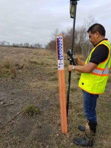
Land Surveying
Hutchison & Associates’ professional surveyors perform complete surveying services using the latest technology available. Playing an integral role in land development, our surveyors research, collect and analyze data, locate boundary corners, take accurate measurements of buildings and other improvements, and use that information to generate survey maps, show monumentation, and identify property ownership.
PURPOSE OF A LAND SURVEY
Land surveys are performed for a variety of reasons. They determine boundaries of properties as well as easements, encroachments, ownership, and are useful in avoiding or solving boundary disputes. These measurements are necessary to guide the development of land and to ensure that developers and land owners have satisfied building code requirements and regulations.
For more survey information, call 281-422-8213 or contact us at our Baytown, TX, location today.
Types of Surveys
Boundary Surveys determine the property lines and corners of tracts of land and parcels.
Construction Surveys, also considered construction staking, provide measurements for reference points that affect construction on a parcel of land such as elevation, horizontal and vertical positions, and dimensions.
Subdivision Surveys, or platting, are used to divide one parcel of land into two or more parcels. These surveys are used for legal titles for each parcel.
Topographic Surveys determine the elevation points of a land parcel showing the contour lines of the natural and man-made features of the property.
As-Built Surveys show any and all improvements made on a property at any given time.
An American Land Title Association (ALTA) Survey
Boundary Surveys
Construction Surveys
Subdivision Surveys
Topographic Surveys
As-Built Surveys

Collecting Survey Data
CONTACT US
Texas Surveying Firm TBPLS #100293-00
